Maps show north and south Whitehouse Farm access routes


The huge site just west of Parklands is earmarked for another 850 homes, and as well as permanent northern access for its residents being built off Broyle Road and a southern road planned, temporary access for lorries will be off Clay Lane through narrow residential roads.
In one of the many comments on the Observer’s Facebook page, Iain Jessup said: “The development will see heavy vehicles along Clay Lane, already a dangerous road with limited pavements, speeding cars and the 56 bus driving oncoming vehicles in to the verge.
“It is unsuitable for lorries and deliveries.”
Advertisement
Hide AdAdvertisement
Hide Ad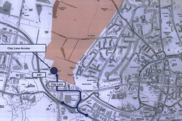
He added: “I fear that residents will be the last consideration for the council or developers.”
The Section 106 planning documents show Clay Lane access to the south-west of the site would be opposite Federick Close, southbound along Clay Lane then eastbound along Fishbourne Road East, through the Tesco Petrol Station roundabout, onto Cathedral Way to access the Fishbourne Roundabout and A27 either east or southbound.
The map does not seem to take into account the fact that construction traffic leaving the site can’t exit the Tesco junction right, so would have to swing around the Chichester College roundabout.
The map for the permanent northern road shows access off Broyle Road near Whitehouse Farm just north of Centurion Way.
Advertisement
Hide AdAdvertisement
Hide AdRather than sending traffic through Parklands down Sherborne Way to the A27, the ‘prescribed route’ is for cars to be funnelled towards the centre of the city, down St Paul’s road, onto the Northgate Gyratory, west along Orchard Street, over the roundabout at the end of West Street, south along Avenue De Chartres to join Via Ravenna and travel westward before joining Cathedral Way and onto the A27.
Details of the proposed southern access are still being formulated, and the head teacher of Bishop Luffa School has rebuffed reports that the school was in a stalemate with developers Miller and Linden Homes over the loss of its playing fields for the new road.
Nick Taunt says he actually suggested the southern access could go through the current school land during early planning meetings if the school was given its own space to the west and land to share with the community.
Mr Taunt said: “We have been talking for some time with the developers about the possible implications of the development of the Whitehouse Farm site. “There was no need to talk further until outline planning permission had been given for the first phase.
Advertisement
Hide AdAdvertisement
Hide Ad“I am pleased that this has now been granted. I look forward to the public consultation so that we can get to grips with the detailed proposals.”
Mr Taunt added: “We have always been neutral on this, we’ve never taken sides for or against.
“We are accepting of things for the benefit of the school and the community this end of Chichester and having fields which are joint use means the community can use the fields in the late afternoon and during the holidays and we use them during the school time is actually a very good use of the space.”
He said the new road would see the school’s main entrance move, along with southern end of Centurion Way.
Advertisement
Hide AdAdvertisement
Hide AdThe school has asked for two seasons of growing for the new fields so they are ready for pupils to use before they lose their land, Mr Taunt added.
You can access all the Phase 1 planning documents for Whitehouse Farm (reference 14/04301/OUT) here: https://publicaccess.chichester.gov.uk/online-applications/applicationDetails.do?activeTab=documents&keyVal=NH1LX5EROY000
Other details about the 750 homes, new school and community centre approved here: https://www.chichester.co.uk/news/politics/first-750-homes-at-whitehouse-farm-approved-1-8467613